|
|
|
|
|
TYPES
OF VOLCA
| ||||||||||
|
|
|
|
||
|
||||
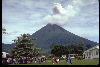
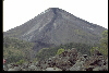
Although they are not as explosive as large silicic caldera complexes, strato volcanoes have caused by far the most casualties of any type of volcano. This is for many reasons. First is that there are so many more strato volcanoes than any of the other types. This means that there will also be lots of people who end up living on the flanks of these volcanoes. Additionally, strato volcanoes are steep piles of ash, lava, and domes that are often rained heavily on, shaken by earthquakes, or oversteepened by intruding blobs of magma (or all of these). This makes the likelihood of landslides, avalanches, and mudflows all very high. Occasionally as well, entire flanks of strato volcanoes collapse, in a process that has been termed "sector collapse". Of course the most famous example of this is Mt. St. Helens, the north flank of which failed during the first stages of the big 1980 eruption. Mt. St. Helens was certainly not the only volcano to have suffered an eruption such as this, however. Two other recent examples are Bezymianny (Kamchatka) in 1956, and Unzen (Japan) in 1792. The 1792 Unzen sector collapse dumped a flank of the volcano into a shallow inland sea, generating devastating tsunami that killed almost 15,000 people along the nearby coastlines.
Another very common and deadly hazard at most strato volcanoes is called a Lahar. Lahar is an Indonesian word for a mudflow, and most geologists use the term to mean a mudflow on an active volcano. Sometimes the word is reserved only for mudflows that are directly associated with an ongoing eruption (which are therefore usually hot), but that starts to make things confusing. It is probably simplest to just call any mudflow on a volcano a lahar. Lahars are so dangerous because they move quickly, and often times a small eruption or relatively small rainstorm can generate a huge lahar. The most recent huge volcanic disaster occurred at a Colombian volcano called Nevado del Ruiz in 1985. This disaster has been well-documented by numerous post-eruption studies. Nevado del Ruiz is a very tall volcano, and even though it lies only slightly above the equator it has a permanent snow and ice field on its summit. On November 13, 1985 a relatively small eruption occurred at the summit. Even though only a little bit of ash fell and only small pyroclastic flows were produced, they were able to melt and destabilize a good deal of the summit ice cap. The ice cap had already been weakened and fractured by a few months of pre-cursor seismic activity. The melted snow and ice, along with chunks of ice, surged down gullies that started high on the slopes, picking up water, water-saturated sediments, rocks, and vegetation along the way. The eruption occurred just after 9:00 pm, and about 2 and a half hours later lahars managed to travel the approximately 50 km down river valleys to the town of Armero. The lahar entered Armero at 11:30 pm as a wall of muddy water nearly 40 meters high, and roared into the city, producing an eventual thickness of 2-5 meters of mud. Somewhere around 23,000 people were almost instantly killed. The path of destruction almost exactly matches similar disasters that occurred in 1595 and 1845. It also almost exactly covered the highest lahar-designated area on the volcanic hazard map that had been prepared prior to the 1985 eruption. Unfortunately that map had not yet been distributed by the time of the 1985 eruption.
Another place that is starting to get really tired of lahars is Pinatubo, in the Philippines. The 1991 Pinatubo eruption was the second largest this century (after Katmai in 1912), and deposited a huge volume of relatively loose pyroclastic material on already-steep and gullied slopes. Additionally, the rainfall in the Philippines is very high. The combination of all this unconsolidated material and heavy rainfall has generated probably hundreds of lahars, some of which have been enormous. Timely evacuation meant that only a couple hundred people were killed directly by the 1991 eruption. Many times that many have been killed or injured by lahars since the 1991 eruption. These lahars will continue to be a problem for decades after the big eruption.
Rhyolite
Caldera Complexes
Rhyolite caldera complexes are the most explosive of Earth's volcanoes but often don't even look like volcanoes. They are usually so explosive when they erupt that they end up collapsing in on themselves rather than building any tall structure (George Walker has termed such structures "inverse volcanoes"). The collapsed depressions are large calderas, and they indicate that the magma chambers associated with the eruptions are huge. In fact, layers of ash (either ash falls or ash flows) often extend over thousands of square kilometers in all directions from these calderas. Fortunately we haven't had to live through one of these since 83 AD when Taupo erupted. Many rhyolite caldera complexes, however, are the scenes of small-scale eruptions during the long reposes between big explosive events. The vents for these smaller eruptions sometimes follow the ring faults of the main caldera but most often they don't. The origin of these rhyolite complexes is still not well-understood. Many folks think that Yellowstone, for example, is associated with a hotspot. However, a hotspot origin for most other rhyolite calderas doesn't work; they occur in subduction-related arcs. Examples of rhyolite caldera complexes include Yellowstone, La Primavera, Rabaul, Taupo, Toba, and others.
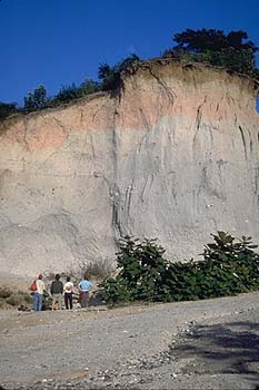
This is an outcrop in the Los Chocoyos ignimbrite, the product of one of the most powerful eruptions known...
Monogenetic fields also don't look like "volcanoes", rather they are collections of sometimes hundreds to thousands of separate vents and flows. Monogenetic fields are the result of very low supply rates of magma. In fact, the supply rate is so spread out both temporally and spatially that no preferred "plumbing" ever gets established; the next batch of magma doesn't have a pre-existing pathway to the surface and it makes its own. A monogenetic field is kind of like taking a single volcano and spreading all its separate eruptions over a large area. There are numerous monogenetic fields in the American southwest and in México, including Michoacan-Guanajuato, San Martín Tuxtla, Pinacate, and the San Francisco volcanic field
Flood basalts are yet another strange type of "volcano." Some parts of the world are covered by thousands of square kilometers of thick basalt lava flows - individual flows may be more than 50 meters thick, and individual flows extend for hundreds of kilometers. The old idea was that these flows went whooshing over the countryside at incredible velocities (e.g., like a flash flood). The new idea is that these flows are emplaced more like flows, namely slow moving with most of the great thickness being accomplished by injecting lava into the interior of an initially thin flow. The most famous US example of a flood basalt province is the Columbia River Basalt province, covering most of SE Washington State and extending all the way to the Pacific and into Oregon. The Deccan Traps of NW India are much larger and the Siberian Traps are even larger than that (but poorly understood). The Ontong Java plateau may be an oceanic example of a flood basalt province.
Mid-ocean
ridges
This is a map of the major oceanic spreading centers. This is sometimes considered to be one ~70,000 km-long volcano. Here, the plates are pulled apart by convection in the upper mantle, and lava intrudes to the surface to fill in the space. Or, the lava intrudes to the surface and pushes the plates apart. Or, more likely, it is a combination of these two processes. Either way, this is how the oceanic plates are created.
The lava produced at the spreading centers is basalt, and is usually abbreviated MORB (for Mid-Ocean Ridge Basalt). MORB is by far the most common rock type on the Earth's surface, as the entire ocean floor consists of it. We know that spreading occurs along mid-ocean ridges by two main lines of evidence: 1) the MORB right at the ridge crest is very young, and it gets older on either side of the ridge as you move away; and 2) sediments are very thin (or non-existent) right near the ridge crest, and they thicken on either side of the ridge as you move away. Mid-ocean ridges are also the locations of many earthquakes, however, they are shallow and generally of small magnitude.
We have never witnessed an eruption along a mid-ocean ridge, although a few times earthquake swarms have been detected along them (mainly by secret US Navy listening devices). When scientists have investigated soon after, fresh-looking basalt, plumes of hot chemical-laden water, and recently-killed marine organisms have been observed, indicating that an eruption almost certainly had occurred.
SOME
HOT PICTURES
Figure.
Volcanic earthquakes that occurred at Asama volcano (Asama Volcano Observatory,
ERI-Univ. tokyo)
View of the summit crater (April 2002, taken by E. Koyama)
Figure. Volcanic earthquakes that occurred at Asama volcano (Asama Volcano Observatory, ERI-Univ. tokyo)
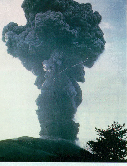
Eruption
at Asama Volcano in 1973
 Yomiuri Shinbun
 Nikkei Shinbun
 Asashi Shinbun